Maps and relevant documents for Beacon Fen Energy Park will appear here so local communities can access information easily and quickly.
Consultation Documents
Preliminary Environmental Information Report
Non Technical Summary
00 Content, Glossary and Reference List
Content, Glossary and Reference List
01 Introduction
Appendix 1.3 Arboricultural Impact Assessment
Appendix 1.4 Ground Conditions Desk Study
Appendix 1.5 Statement of Expertise
Figure 1.4 Full Extents Layout
Figure 1.5 Indicative Mitigation Layout
Click here to download all documents in this section
02 Proposed Development
03 Alternatives & Design Evolution
Alternatives & Design Evolution
Figure 3.1 Alternative Cable Corridors
Figure 3.2 Site Layout Alternatives (Substation & BESS)
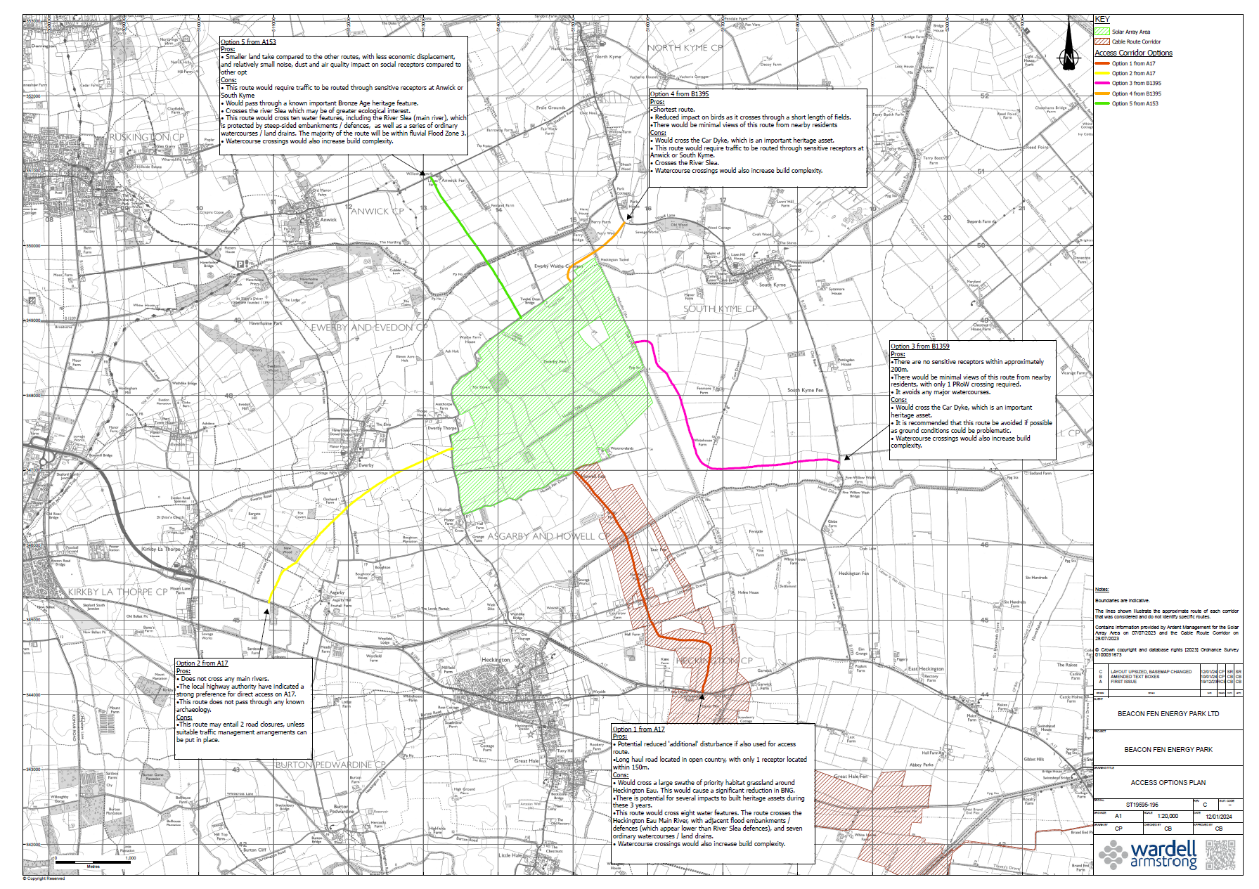
Figure 3.3 Alternative Access Routes
Figure 3.4 Initial Cable Corridor Refinement
Click here to download all documents in this section
04 Scope & Methodology
Appendix 4.1 Cumulative Assessment: Long List
Appendix 4.2 Cumulative Assessment: Short List
Figure 4.1 Cumulative Development: Nationally Significant Infrastructure Projects
Figure 4.2 Cumulative Development: Local
Click here to download all documents in this section
05 Consultation
06 Landscape & Visual
Appendix 6.1 Landscape and Visual Legislation and Policy
Appendix 6.2 Landscape and Visual Methodology
Appendix 6.3 Landscape Character
Appendix 6.4 Visual Assessment
Figure 6.1 Bareground Zone of Theoretical Visibility (Drawing ST19595/110);
Figure 6.2 Screened Zone of Theoretical Visibility (Drawing ST19595/111);
Figure 6.3 Topography (Drawing ST19595/112);
Figure 6.4 Sensitive Receptors and Designated Sites (Drawing ST19595/113);
Figure 6.5 Recreational Receptors (Drawing ST19595/107)
Figure 6.6 Landscape Character Regional Level (Drawing ST19595/114);
Figure 6.7 Landscape Character – Local level (Drawing ST19595/108);
Figure 6.8 Landscape Character – The Site (Drawing ST19595/109)
Figure 6.9 Baseline Panorama Viewpoint 1 (Drawing ST19595/060)
Figure 6.10 Baseline Panorama Viewpoint 2 (Drawing ST19595/061)
Figure 6.11 Baseline Panorama Viewpoint 3 (Drawing ST19595/062)
Figure 6.12 Baseline Panorama Viewpoint 4 (Drawing ST19595/063)
Figure 6.13 Baseline Panorama Viewpoint 5 (Drawing ST19595/064)
Figure 6.14 Baseline Panorama Viewpoint 6 (Drawing ST19595/065)
Figure 6.15 Baseline Panorama Viewpoint 7 (Drawing ST19595/066)
Figure 6.16 Baseline Panorama Viewpoint 8 (Drawing ST19595/067)
Figure 6.17 Baseline Panorama Viewpoint 9 (Drawing ST19595/068)
Figure 6.18 Baseline Panorama Viewpoint 10 (Drawing ST19595/069)
Figure 6.19 Baseline Panorama Viewpoint 11 (Drawing ST19595/070)
Figure 6.20 Baseline Panorama Viewpoint 12 (Drawing ST19595/071)
Figure 6.21 Baseline Panorama Viewpoint 13 (Drawing ST19595/072)
Figure 6.22 Baseline Panorama Viewpoint 14 (Drawing ST19595/073)
Click here to download all documents in this section
07 Ecology
Appendix 7.3 Preliminary Ecological Appraisal
Appendix 7.4 Great Crested Newt Habitat Suitability Index and eDNA Report
Appendix 7.5 Wintering Bird Report
Appendix 7.6 Breeding Bird Report
Appendix 7.7 Bat Activity Survey
Appendix 7.9 Riparian Mammals Report
Figure 7.1 International Sites within 20km of the Site
Figure 7.2 SSSI within 10km of Site
Figure 7.3 Local Wildlife Sites within 2km
Figure 7.4 Ancient Woodland/Priority Habitat within 1km of the Site
Click here to download all documents in this section
08 Cultural Heritage
Appendix 8.1 Legislation and Policy
Appendix 8.2 Aerial Assessment Report
Appendix 8.3Geophysical Survey Reports
Appendix 8.4 Trial Trenching Update
Figure 8.1: Designated Heritage Assets within 5km
Figure 8.2: Solar Array Field Reference
Figure 8.3: Non-Designated Heritage Assets within 2km
Figure 8.4: Interim Trial Trenching Progress
Click here to download all documents in this section
09 Access & Traffic
Appendix 9.1 Transport Planning Policy
Appendix 9.2 Access and Traffic Related Correspondence
Figure 9.1 Access Routes and most recent traffic counts
Figure 9.2 Forecasts of traffic on selected roads in 2028 and 2051
Figure 9.3 Locations of road traffic accidents
Figure 9.4 Construction related one-way heavy vehicle movements
Click here to download all documents in this section
10 Noise & Vibration
Appendix 10.1 Policy Legislation and Guidance
Appendix 10.2 Noise Survey Results
Figure 10.1 Proposed Site, Existing Noise Sensitive Receptors and Measurement Positions
Figure 10.2 Operational Noise Contours – Light Periods
Figure 10.3 Operational Noise Contours – Dark Periods
Click here to download all documents in this section
11 Water Resources & Flood Risk
11 Water Resources & Flood Risk
Appendix 11.1 Flood Risk Assessment
Appendix 11.2 Hydrological Walkover Survey
Appendix 11.3 Abstractions within 2km of the Site
Appendix 11.4 Summary of Watercourse Crossings
Appendix 11.5 Planning Policy & Legislation
Figure 11.1 Surface Water Catchment
Figure 11.2 Abstraction and Discharges
Figure 11.3 Superficial Geology
Figure 11.5 Site Walkover Photograph Locations
Figure 11.6 Watercourse Crossings
Click here to download all documents in this section
12 Climate Change
Appendix 12.1 Climate Change Guidance and Legislation
Click here to download all documents in this section
13 Glint
Appendix 13.1 Legislation, Policy and Guidance
Appendix 13.2 Zone of Theoretical Visibility
Appendix 13.3a ForgeSolar Glint Report: Road, Railway & Aviation
Appendix 13.3b ForgeSolar Glint Report: OPs1-40
Appendix 13.3c ForgeSolar Glint Report: OPs41-55
Appendix 13.4 Mathematical Equations
Click here to download all documents in this section
14 Soils & Agricultural Land
Appendix 14.2: Agricultural Land Classification Report, Beacon Fen (Wardell Armstrong, 2023)
Click here to download all documents in this section
15 Socio-Economic
Appendix 15.1 Legislation, Policy and Guidance
Appendix 15.2 Consultation to Date
Figure 15.1 Direct Area of Influence
Figure 15.2 Indirect Area of Influence
Figure 15.3 Public Rights of Way
Click here to download all documents in this section
16 Air Quality
Appendix 16.1 Legislation, Policy and Guidance
Appendix 16.2 Assessment Methodology
Appendix 16.3 Copies of Relevant Correspondence
Click here to download all documents in this section
17 Summary